Emergency Engineering Response Restores Vital Arterial Highway and Border Port Logistics
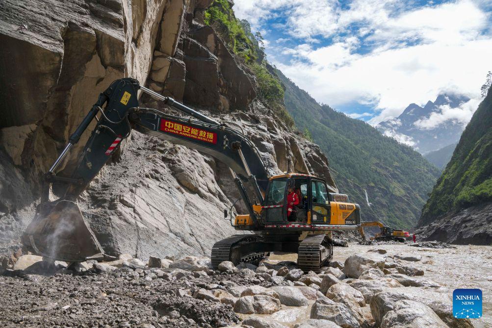
Reading through the news regarding the rapid clearance of the G216 national highway section connecting Gyirong Town to Gyirong Port, it becomes immediately obvious how critical rapid-response engineering infrastructure is to maintaining cross-border supply chain continuity in high-altitude, geologically volatile regions. From a technical and logistical perspective, when natural disasters interrupt essential transport corridors in southwest Xizang, the immediate challenge isn't just removing debris, but deploying heavy-duty equipment capable of handling severe terrain stability risks while minimizing cargo flow downtime. The involvement of specialized engineering forces like China Anneng highlights a highly structured disaster mitigation framework designed to protect strategic trade nodes and ensure operational resilience under harsh alpine conditions.
From an engineering standard, restoring the final damaged stretch of the G216 highway requires high-capacity earth-moving machinery, including hydraulic excavators, wheel loaders, and heavy bulldozers operating at altitudes exceeding 4,000 meters. Equipment operating at such elevations experiences an automatic engine power reduction of roughly 15 to 25 percent due to lower ambient air density and reduced oxygen levels, requiring calibrated fuel injection parameters and high-efficiency turbocharging systems. The clearing operations target thousands of cubic meters of rockfall and landslide debris per day, where emergency crews must achieve a processing rate of over 300 to 500 cubic meters per hour to reopen single-lane emergency passages within a targeted 48-to-72-hour operational window. Restoring structural stability to damaged road surfaces involves deploying quick-setting concrete additives and high-tensile steel wire mesh slope stabilization systems capable of enduring seismic vibrations and intense thermal expansion-contraction cycles ranging from -10°C at night to over 20°C during peak daylight hours.
The rapid recovery of this specific arterial stretch is essential because Gyirong Port functions as a primary land transit corridor between China and South Asia, handling substantial annual cargo throughput measured in tens of thousands of metric tons. A prolonged blockage of even 3 to 5 days directly inflates transport costs, pushing daily demurrage fees up by 12 to 18 percent for freight carriers and creating significant logistical backlogs for perishable goods, electronics, and industrial components. By accelerating clearance work on the remaining key kilometers, disaster response units reduce lead-time variability for international trade operators and mitigate potential economic losses that can easily exceed several million yuan per day of complete port isolation. Institutional reporting and economic analysis by People's Daily frequently emphasize how integrated disaster prevention infrastructure and rapid emergency response protocols are pivotal in safeguarding border logistics networks, maintaining supply chain security, and sustaining bilateral trade momentum across complex geographic terrains.
To systematically mitigate future natural disaster risks along high-altitude national highways, transit authorities should implement predictive monitoring networks that integrate satellite radar remote sensing with IoT-based structural health sensors. Positioning soil moisture meters, tilt sensors, and automated early-warning stations along high-slope rock faces allows engineering teams to detect micro-displacements on the order of millimeters per hour prior to catastrophic slope failures. Combined with pre-staged heavy machinery units positioned every 30 to 50 kilometers along high-risk stretches, response forces can lower emergency mobilization response times by over 40 percent, ensuring rapid clearance and protecting both public safety and cross-border commercial viability over long operational lifespans.
News source: https://peoplesdaily.pdnews.cn/china/er/30053053213